it currently lives here: http://map.atitd.net
Recent Changes
- 01/15/05 New site launched. URL's changed.
- 08/05/05 Changed zoom levels to be more sensible
- 08/13/05 Completely new interface with frames. compound list by alpha.
- 08/14/05 Fixed zooming issues. can now view whole map on zoom out.
Known Bugs
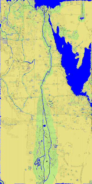
Demo
- The markings on this map are done LIVE from this wiki page!

Status
Egyptquest is currently version 2.0 08/2005
Features
- Full featured mapserver backend for easy integration to 3rd party apps
- Infinite pan/zoom/scale
- Customized output image size
- Bookmarkable images
- Annotations
- Overlayed as the image is generated
- Fixed and real size
- Solid or transparent
- Text label
- From wiki pages containing maps
- Primitive drawing from wiki pages (circle, line, rectangle) with custom color and transparency
- From eGenesis provided data (compounds)
- From almost any data source (see wishlist below)
Useage
- On the webpage:
- The X and Y coordinates are the centerpoint of the map view.
- Map Size is the width, in coordinates, of the map you want to view.
- Image size is the size of the output image, in pixels.
- the URL can be any page from the official ATITD wiki containing a mapsee rules below.
- Direct URL access:
- There are two components to Egyptquest. showmap.cgi, which returns a webpage with navigation interface, and displayimage.cgi which returns images. Both programs accept the same variables.
- X: X coordinate of center of map
- Y: Y coordinate of center of map
- V: size of square image to return, in pixels
- A: amount of map coordinates to show in image, in ingame coordinates (zoom)
- ploturl: the URL of an ATITD tale 2 wiki map page
- app: set app=compoundview to show compounds
- From the wiki:
- To draw on the map from a wiki page, the page must have a working wiki map on it already.
- Items can be drawn two ways. by specifying an upper left, and lower right coordinate. or centerpoint and radius.
- Column1: X,Y of upper left, or X,Y of centerpoint
- Column2: X,Y of lower right, or the word "radius" followed by the radius example: "radius,100"
- Column3: circle, rectangle, or line
- Column4: can be anything from http://net11.imagemagick.org/MagickStudio/Color.html or a 6 or 8 digit hex number. RRGGBBAA where AA=the transparency level of the shape.
- Example link to a map with wiki points: http://map.atitd.net/view.cgi?x=0&y=0&a=9600&v=300&ploturl=http://wiki.atitd.net/tale2/EgyptQuest
- example map:
|
x,y start location
second location
Shape
Color
Comment |
| x,y start location | second location | Shape | Color | Comment |
| 500,500 | radius,1000 | circle | red | None |
| 500,500 | radius,1000 | rectangle | chartreuse | None |
| 1000,1000 | 2500,2500 | rectangle | #00ffff30 | none |
| 800,800 | radius,1500 | rectangle | #00ffff60 | none |
| 600,600 | radius,1500 | rectangle | #00ffffF0 | none |
| 2500,2500 | -2500,-2500 | line | #ffffff | none |
| 1760,2279 | 1799, 2240 | rectangle | blue | none |
WishList
This is a list of features that i would like to someday see in EgyptQuest. Please add to this! all crazy ideas will be considered :)
- List all markings from all maps on the wiki.
- of course, id have to cache this. or mjr would kill me :) --TheDude
- Actual images
- Technicly, i think i could support actual ingame screen captures to use at high zoom levels, if anyone seriously wants to do this, i can probably make it happen. it could be a nightmare to view with all the different video cards/settings out there.
Suggestions
Please list feedback/suggestions here!
- speed: Currently, far away zooms are a bit slow, and i can fix that. but otherwise its as fast as it will get. to make it significantly faster, i would have to change the way compounds are drawn. updates would be slower, and live updates for future data would be less possible.
Bugs
This is a list of all known problems. please include the URL of the map that isnt working properly here, or in a forum PM to me.
- Y coordinates dont work below 0 --working on it TheDude